Kilcashel - Our Findings to Date
Kilmovee, County Mayo, Ireland
Mapping
In addition to 10 sites that archaeologists have known about for many years in Kilcashel, we've identified 27 sites of archaeological and historical importance from 19th century maps including houses, structures, lime kilns, mill buildings, quarries and wells.
Two of these sites formed part of Barney's Mill, a 19th century mill and kiln complex that represented the industrial heart of Kilcashel (and Kilmovee), following the Industrial Revolution. Barney's Mill was located at the current site of the Kilmovee Swimming Pool, which was built in the 1980's.
We've mapped the development of Kilcashel townland during the early 19th century right up to today. Bogs and rock filled land were replaced with ladder style stone wall field systems.
The map analysis also shows that the streams flowing through Kilcashel were canalised to allow for the straight edges of the 19th century field systems.
Geophysical Surveys
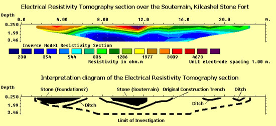
A geophysical survey has occurred inside the Kilcashel Stone Fort. A technique known as Electrical Resistivity Tomography (or ‘ERT') can give us an idea of what archaeological features look like under the ground. Three ERT surveys were carried out on top of an underground chamber known as a souterrain (sometimes referred to as caves or tunnels). The souterrain is located on the inside edge of Kilcashel Stone Fort, aligned west to east.
The stone walls and ceiling of the souterrain are clearly visible in the geophysical data as a compact zone of high electrical resistance.
The original construction trench or gallery that was dug to contain the souterrain can also be seen as a zone of lower electrical resistance which surrounds the stone chamber.
Another zone of high electrical resistance was located on the western side of the southernmost ERT line and this might be related to the wall foundations of the Stone Fort.
Other low resistance zones suggest the presence of ditches within the Stone Fort.
Field Survey of Monuments
We've confirmed that 3 of the 4 ‘V' shaped steps in the walls of the Stone Fort have an alignment to the cardinal points of the compass at North, East and South. The fourth set of steps is ‘offline', (the wall-chamber entrances are aligned due West and are ‘in the way' of the steps.
Walkover Survey
Upon the plateau of the narrow esker in Esker Wood (to the south of the Stone Fort), there are the remains of a possible trackway, elevated high above the surrounding bog land.
What happens next?
In 2010 we are carrying out an extensive program of geophysical surveys inside the Kilcashel Stone Fort. We're hoping to map a souterrain in the fort and identify areas of human activity.
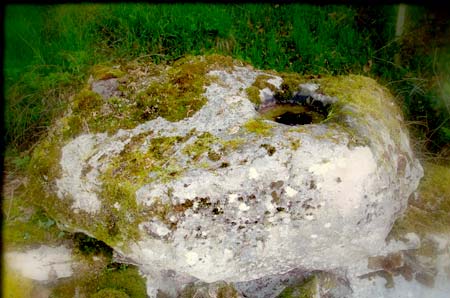
Another area of investigation that we're hoping to carry out in 2010 is a small geophysical survey upon the surface of a Kilcashel Bullaun Stone, to try and determine if it was ever used for grinding up industrial ores.
This Bullaun Stone currently sits upon at a stone wall; it was previously contained within an enclosure referred to as Father Hugh Henry's Fort, where folklore tells us it was used as a mass rock. Bullaun Stones are often found at ecclesiastical sites but their function is unclear - recent research has suggested the cups could have been used to grind up industrial ores. This Bullaun Stone will be analysed for signs of strong magnetism that might suggest an industrial use.