History and Archaeology of Kilcashel
Kilmovee, County Mayo, Ireland
Kilcashel - the wood of the stone fort
The townland name of Kilcashel is from the Anglicised version of the Irish Coill an Chaisil, which means 'the wood of the stone fort'. Kilcashel is a historically rich but sparsely populated townland, 250m south of Kilmovee village, in northeast County Mayo. The townland is located upon a long sandstone ridge and contains pasture fields, woodland and scrub over a 107 hectare area. Two streams form natural boundaries on the south, east and north sides of the townland and flow in to the Lung River, 2km to the east. The streams on the SE corner of the townland border also represent the county border between Mayo and Roscommon.
The Archaeology of Kilcashel
Ten recorded archaeological sites are known for the Kilcashel Landscape Project study area:
- a Bronze Age fulachta fiadh (a cooking site, made up today by a mound of burnt stones)
- an undated enclosure (substantially destroyed in the 20th century)
- three Early Medieval cashels (circular Stone Forts)
- a bullaun stone (a large boulder with a smooth cup cut into it)
- two Early Medieval souterrains (man-made underground chambers)
- two Early Medieval house sites
Nine more archaeological sites are located within a 1km radius of Kilcashel and a further 40 more within a 2km radius. Several archaeological features have already been identified by the Kilcashel Landscape Project by examining early maps - these show that Kilcashel underwent significant landscape changes during the mid-19th century as scrub was cleared, bog was drained and the land sub-divided into small, regular field-systems, with boundaries comprised of local stone quarried from rock outcrops or picked up as loose field stones.
The Stone Forts of Kilcashel
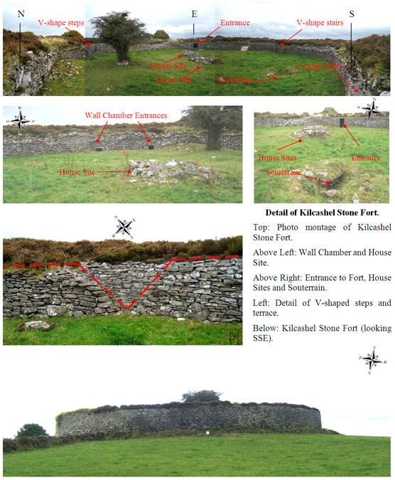
The most significant group of archaeological features in Kilcashel are the three stone forts or cashels that lie upon a sandstone ridge, just above the 100m contour line. Sadly, two of these have been substantially destroyed leaving the Kilcashel Stone Fort as the only surviving example in the study area. The Stone Fort is a National Monument and its preservation is exceptional. It measures 30m in diameter and is constructed of a single circular wall which is 5m thick and 3m high. Inside the Stone Fort are two creep-ways in the circular wall of the fort leading to an internal wall-chamber; a formal entranceway with a lintel stone; four sets of V-shaped steps set into the wall; wall terracing; a souterrain; and (finally) two collapsed house sites.